More than 70,000 people in two states have lost power, as damaging winds, huge waves and heavy rainfall from the approaching Tropical Cyclone Alfred begin to batter coastal communities.
Forecasters said Alfred may make a “prolonged” coastal crossing, as the category two storm moved slowly towards landfall in south-east Queensland.
The Bureau of Meteorology was updating its tracking forecast every hour, and the corridor for Alfred to cross the mainland coast had narrowed. It was now likely between Noosa and Beenleigh about 11am on Saturday.
Forecasters have said the cyclone’s wayward behaviour as it approaches heavily populated parts of south-east Queensland was creating “considerable uncertainty” in predicting where and when the system could make landfall.
Alfred performed another pirouette on Thursday evening, looping around on its path and further delaying its progress.
Alfred’s slow progress to the mainland could prolong already severe conditions to the south of its projected path, particularly in parts of the Gold Coast and northern New South Wales already experiencing coastal erosion from wild surf, intense rain and potential flooding.
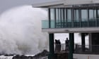
The waves had swallowed a large chunk of some Gold Coast beaches, turning tide lines into pseudo three-metre cliff faces.
Thousands of people in parts of the NSW northern rivers were told to leave their homes on Thursday night, including residents in Lismore’s CBD, north and south. The community was devastated by flooding in 2022. In total 29,000 dwellings in NSW were under evacuation orders as of midday Friday.
Evacuation orders had been issued as far south as the Nambucca shire – more than 400km south of the Queensland-NSW border – with river levels expected to rise on Friday morning.
Energy providers in Queensland and NSW said that large numbers of customers had lost power – about 40,000 north of the Tweed and 36,000 to the south of the border.
The main issue had been heavy winds bringing down trees and power lines. Authorities warned there might be delays in power being reconnected, and that transmission companies would do so only when it was safe.
The NSW State Emergency Service said on Friday it had already responded to 3,495 incidents. Overnight it responded to five flood rescues.
Alfred was forecast to remain a category two tropical cyclone until it reached Moreton Bay. If it comes through the bay, there was a chance the system may lose some intensity as it passes the bay islands.
Matthew Collopy, a senior forecaster from the Bureau of Meteorology, said it would most likely cross the mainland coast as a category one cyclone.
“It’s important to note that exact track is still uncertain and that tropical cyclone warnings will now be updated every hour based on the latest radar and satellite imagery,” Collopy said.
“Destructive wind gusts up to 150km/h are possible about the exposed island coasts and coastal locations near and to the south of the system,” he said.
“As the cyclone moves across Moreton Bay islands, it is expected to weaken from a category two to a category one system. That will mean that destructive winds are unlikely for Brisbane itself, but damaging wind gusts to 120km/h are expected and they will develop quickly as the system approaches.”
Collopy said the main concern would quickly become potential for flooding.
after newsletter promotion
“In terms of the flooding, those rainfall amounts we’re seeing will be the major concern as we move forward,” he said.
“The flash flooding due to those intense rainfalls as well as widespread minor to major riverine flooding.”
The Queensland premier, David Crisafulli, said there had not yet been any inundation from homes from storm surge and that this is “really, really good news”.
“There’s another high tide this afternoon and a slightly larger one tomorrow morning – slightly larger than this afternoon – so we’ll continue to watch that as the system approaches but particularly good news there was no inundation overnight,” Crisafulli said.
The BoM’s tracking maps were a “best estimate”, using information from a number of models that predict how the cyclone may behave. Forecasters were accurately able to provide communities with significant warning that Alfred would turn west on Tuesday and head towards the coast.
But as if to underscore the difficulty of giving precise information, Alfred was not taking a direct route back to Brisbane.
Having lingered in the Coral Sea for almost a fortnight, Alfred had now performed several pirouettes since turning and making an unsteady course towards the mainland.
Late on Thursday the system performed another loop, further delaying its progress to the coast.
“The system maintains a general westerly track, however it recently completed a small loop, similar to previous loops that have occurred over the past few days,” the BoM said in its update on Friday.
“It would not be a surprise to see further short-term variations in the track as Alfred nears the coast, which will be an important consideration when following the system on radar.”
Read more of Guardian Australia’s Tropical Cyclone Alfred coverage:
Source: www.theguardian.com